Lorentz


Lorentz National Park is located in the Indonesian province of Papua, formerly known as Irian Jaya (Western New Guinea), with an area of 2.450.000 hectares, it is the largest national park in South-east Asia. In 1999 Lorentz National Park was declared a 'World Heritage Site' by UNESCO.

An outstanding example of the biodiversity of New Guinea, Lorentz is one of the most ecologically diverse national parks in the world. It is the only nature reserve in the Asia Pacific region to contain a full altitudinal array of ecosystems ranging through marine areas, mangroves, tidal and freshwater swamp forest, lowland and montane rainforest, alpine tundra, andequatorial glaciers. At 4.884 meters, Puncak Jaya (formerly Carstensz Pyramid) is the tallest mountain between the Himalayas and the Andes.

Located at the meeting point of two colliding continental plates, the area has a complex geology with on-going mountain formation as well as major sculpting by glaciation and shoreline accretion which has formed much of the lowland areas. These processes have led to a high level of endemism and the same area supports the highest level of biodiversity in the region. The area also contains fossil sites that record the evolution of live on New Guinea.

As well as very high biological diversity, the park also has other unique features such as the glaciers on Puncak Jaya and a river that disappears under the ground for several kilometres in the Baliem Valley (Lembah Baliem).

Lorentz National Park is named for Hendrikus Albertus Lorentz, a Dutch explorer who passed through the area on his 1909 - 1910 expedition.

There are 34 vegetation types that make up the forest area of the park, including swamp forest, riparian forest, sago forest, peat forest, coastal forest, coral reef, slope/flat land rainforest, hillside rainforest, montane forest, grassy plains and moss-covered areas.

Among the species of plant that grow in this park are Nipah (Nypa fruticans), Bakau (Rhizophora apiculata), Pandanus julianetii, Colocasia esculenta, Podocarpus pilgerii, and Nauclea coadunata.

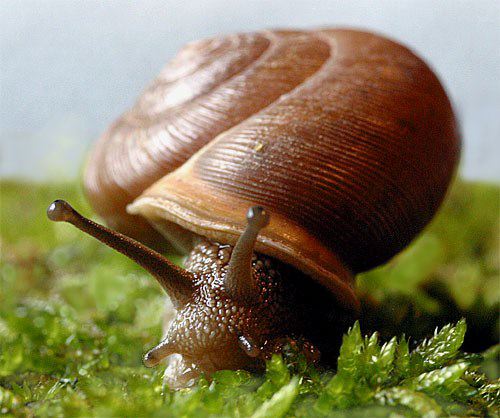
There are about 630 species of birds (some 70 % of the total number of bird species in Papua), 123 species of mammals, and various other animal species. Some of the more interesting species of bird are two species of 'Cassowary'. 31 Dove and Pigeon species, 31 species of Cockatoo, 13 species of Kingfisher, 29 species of Sunbird, and 20 endemic species that are found nowhere else in the world, including the Snow Quail (Anurophasis monorthonyx) and the Long-tailed bird of Paradise (Paradigalla caruneulata). The mammal species include the Long-beaked Echidna (Zaglossus buijnii bruijnii), Short-beaked Echidna (Tachiglossus aculeatus), and four species of Cuscus as well as Wallabies, Forest Cats and Tree Kangaroos.

The park's high biological diversity is matched by its marvellous cultural diversity. It is estimated that the some of these cultures have existed in this area for more than 30.000 years. This is the home of tribes such as the Nduga, Dani Barat, Amungme, Sempan, and Asmat. It is quite possible that ther are still other communities living in very isolated areas who have never had contact with the modern world at all.

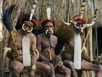
The Asmat are well known for their skill at chiselling wood into fine statues. According to their belief, the tribe is identical to the forest or trees. The trunk of a tree symbolizes the body of human being; the branches are the arms, and the fruit symbolizes the human head. Their ancestors-spirits, they believe, dwell in the trees. As such, the Asmat accord great respect to trees. River, mountain and other natural features are similarly honoured.

Lorentz National Park stretches for over 150 km, from Papua's central cordillera mountains in the north to the Arafura sea in the south. The park can be divided into two very distinct zones : the swampy lowlands and the high mountain area of the central cordillera. The central cordillera it self can be subdivided in the easthern part and the western part on the basis of geology and vegetation types.

The central mountain ranges are the southern portion of two colliding continental plates, which are causing the mountain range to rise. The lowering and rising of the sea level during the glacial and interglacial periods of the Pleistocene epoch, along with continuous activity in the mobile belt which characterizes the contact zone of the two colliding lithosperic plates, has continued to promote the great biodiversity of the island of New Guinea in general, and in the Lorentz area in particular. Large tracts of the mountain range and especially the area formed by the traditional lands of the Amungme (or Amung) are rich in mineral deposits, especially gold and copper.

The Carstensz/Puncak Jaya section of the Jayawijaya mountain range still retains small ice caps. It is one of only three equatorial sufficiently high altitude to retain permanent ice. The main snowfields comprise five separate areas of ice on the outer margins of Mount Puncak Jaya. These include two small fields which feed the Meren and Carstensz glaciers and a small hanging glacier on the Carstensz Pyramid.


Declared by Minister of Forestry No. 154/Kpts-II/1997. March 19, 1997.

Teluk Cendrawasih


Teluk Cendrawasih National Park is the largest marine national park of Indonesia, located in Cendrawasih Bay, West Papua province, Indonesia, South-East of Bird's Head Peninsula. It includes the islands of Mioswaar, Nusrowi, Roon, Rumberpon and Yoop. The park protects a rich marine ecosystem, with over 150 recorded coral species, for which it is considered a potential World Heritage Site. The Park is the largest marine national park of which 89.8 % of its area is marine.

Extending over 1.453.500 hectares, the national park includes coastal and mangrove ecosystem (0,9 %), coral reefs (5,5 %), island tropical forest ecosystem (3,8 %) and marine water (89,8 %). Some 46 species plant have been recorded on the island, dominated by  Bakau (Bruguiera sp.), Api api (Avicennia sp.), Nipah (Nypa fruticans), Sagu (Metroxilon sagu), Cemara laut (Casuarina equisetifolia), and Ketapang (Terminalia catappa).

The coral reef ecosystem forms part of the Coral Triangle region. In the park, 150 species of coral have been recorded, consisting of 15 families and distributed on the shores of 18 island. Among these are colonies of Blue coral (Heliopora coerulea), Black coral (Antipathes sp.), Leptoseris species, Mycedium elephantotus, and Alcyonaceae and soft corals. The  percentage of  live coral  coverage  varies  from  between 30 - 40 % to 64 - 65 %.

Over 209 fish species inhabit the bark among them : Butterflyfish, Damselfis, Parrotfish, Rabbitfish, Clownfish and Sharks. Species of Mollusc include Cowries (Cyparea spp.), Strombidae (Lambis spp.), Cone shell (Conus spp.), Trumpet triton (Charonia tritonis) and Giant clam (Tridacna gigas).  Four species of turtle are common in the park : The Hawksbill turtle (Eretmochelys imbricata), Green turtle (Chelonia mydas), Olive Ridley turtle (Lepidochelys olivaceae), and Leatherback turtle (Dermochelys coriacea).  Mammals include Dugong (Dugong dogon), Coconut crab (Birgus latro), Blue  whale (Balaenoptera musculus)  and  Dolphins and Sharks.

There is a natural cave with ancient remains, thermal springs containing sulphur without salt on Mioswaar island, and an underwater cave with a depth of 100 feet in Tanjung Mangguar. Remain form the 18 th century can still be found in several places, such as Wendesi, Wasior, and Yomber. Many Christians visit the church in Yende village (Roon island) to have a look at a bibble which dates from 1898.

About 14.000 people live in 72 villages within the park. Several Austronesian languages are spoken in the area which form part of the Cenderawasih languages branch and include : Wandamen, Dusner, Meoswar, Roon and Yeretuar. Most of the park is part of Teluk Wondama Regency of West Papua province, while the eastern part is Nabire Regency of Papua province.

Point of tourism to visit are Nusrowi island, Mioswaar island, Rumberpon island as we can observe wildlife such as birds, deer breeding, marinetourism, diving and snorkelling. Windesi and Yoop island are to observe whales and dolphins. Roon island is to observe bird species, diving, snorkelling, waterfalls and cultural tourism.


Declared by Minister of Forestry No. 8009/Kpts-II/2002, August 29, 2002.

Manusela


Manusela National Park is located on Seram island, in the Maluku archipelago of Indonesia. It is made up of coastal forest, swamp forest, lowland and montane rainforest ecosystem types. Mount Binaiya at 3.027 m above sea level, is the highest of the park's . Seram is remarkable for its high degree of localised bird endemism.

Covering an area of 189.000 hectares, geographical location between 129o06' - 129o46' East and 2o48' - 3o18' South. Temperature 25o - 35o C, rainfall average 1.500 - 2.000 mm/annual. 

Administratively, the Manusela National Park included in the subdistrict of North Seram and the district of South Seram, Central Maluku district, Maluku province, Indonesia. This national park offers a variety of attractive tourist destinations, among other, forest tours, mountain tours, wildlife photography, rock climbing, cross country and sports.

There are four villages in the park : Manusela, Ilena Maraina, Selumena, and Kanike. Manusela is also the name of one  of the mountains within the park, the local ethnic group and their language. In the local language, Manusela means 'bird of freedom'.  

In 1972, two areas in Central Seram were designated as nature reserves : Wae Nua (20.000 hectares) and Wae Mual (17.500 hectares). After survey in 1978, a proposal was made to unite the two areas to form Manusela National Park. Manusela National Park was established in 1997, to protect an area of 189.000 hectares, representing 11% on the land area of Seram island.

Manusela National Park has a variety of forest vegetation, such as coastal forest, swamp forest, river bank, palmah tropical rainforest, mountain forest, and sub alpine forest. Tancang (Bruguiera sexangula), Mangrove (Rhizophora acuminata), Api-api (Avicenia sp.), Lime (Dryobalanops sp.), Pulai (Alstonia scholaris), Ketapang (Terminalia catappa), Pandan (Pandanus sp.), Meranti (Shorea selanica), Benuang (Octomeles sumatrana), Matoa/kasai (Pometia pinnata), Kayu Putih (Melaleuca leucadendron), and various species of orchid.

Other animal in Manusela National Park include the Timor Deer (Cervus timorensis moluccensis), Common Cuscus (Phalanger orientalis orientalis), Water-hagedis Dragon (Hydrosaurus amboinensis), Wild Pig (Sus selebensis), Marbled Cat (Pardofelis marmorata), Giant Skink (Tiliqua gigas gigas), Dugong (Dugong dugon), Common Green Turtle (Chelonia mydas), and various species of butterfly.

There are about 117 species of bird, 14 of them endemic, lik the Eclectus Parrot (Eclectus roratus roratus), Purple-naped Lory (Lorius domicella), Salmon-crested Cockatoo (Cacatua moluccensis), Lazuli Kingfisher (Halcyon lazuli), Sacred Kingfisher (Halcyon sancta), Seram Friarbird (Philemon subcorniculatus), and Moluccan King Parrot (Alisterus amboinensis). The population of endemic Salmon-crested Cockatoo is now gravely threatened due to hunting and the destruction of its habitat.

As for travelers who like adventure, in this park there are many valleys which have the particularity of each. Manusela valley is famous for its natural panorama that smart and cool temperate. Pilianan famous valley with various kinds of butterflies, and Sawai valley popular with sea corals are beautiful.  In addition, in this national park also has six mountains, where Mount Binaiya is the highes mountain.

The presence of the mountains are very supportive of the desire of tourist who like hiking and sport like rock climbing. Meanwhile, the contours of the rising and falling terrain, trails that meander through deep into the woods, and supported by a diverse forest vegetation, provide sufficient space for adventurers to perform various activityes, such as cross country sport, camping, and photographing various unique flora and fauna.

Manusela National Park, there are various facilities, like the gatehouse, tourist guide, information centers and small shops, tower of view, laboratories, rest house, and speed boat rentals are other amenities available here. Travelers who want to stay, can rent the houses located in this park or rent a houseboat there is lots of Sawai Bay. Meanwhile, tourist who want to merge with nature, to camping at various places located in the park.


Declared by Minister of Forestry No. 291/Kpts-II/1997. March 19, 1997.

Wasur


The Wasur National Park forms part of the largest wetland in Papua, province of Indonesia, and has been the least disturbed by human activity. The high value of biodiversity has led to the park being dubbed the 'Serengeti Papua'. The vast open wetland, in particular Rawa Biru Lake, attracts a very rich fauna.

The Wasur National Park is situated in Merauke, Papua. This park has a wildlife habitat and the exact same in Australia, namely savanna forest with various kinds of kangaroo, but the kangaroo in this Wasur smaller compared with the kangaroos in Australia.

Rawa Biru (Blue Swamp)/Wasur Reserve located in the Merauke Region of Papua, the farthest town in the east of Indonesia. Giant termite mounds, long-grass, paper bark trees, acacia, and eucalyptus, much like Australia. The water shelter crocodiles and the curious dugong, and birds are cockatoos, parrots, crowned pigeons, and the fierce cassowary. Native wallabies and the deer introduced in 1913, thrive in the area. The reserve is 60 kilometers (37 miles) from Merauke and the best way to get there is by Jeep during the dry season.

About 70% of total area of the park consists of savanna, while the remaining vegetation is swamp forest, monsoon forest, coastal forest, bamboo forest, grassy plains and large stretches of sago swamp forest. The dominant plants include Mangroves, Terminalia, and Melaleuca species.

The Wasur National park covers an area of 413,810 Ha, average rainfall is about 2,400 mm annually, Temperature 22oC - 30oC, at the geographical location is 140o29' - 141o00' East and 8o04' -  9o07' South. The park provides habitat for a large variety of up to 358 birds species of which some 80 species are endemic to the island of New Guinea. Fish diversity is also high in the region with some 111 species found in the eco-region and a large number of these are recorded from Wasur. The Park's wetland provides habitat for various species of lobster and crab as well.

Wasur National Park is the habitat for a number of rare and endemic species. Red-listed species known to be present in viable population are Southern Crowned Pigeon and New Guinea Harpy Eagle, Dusky Pedemelon, Black-necked Stork, Fly River Grassbird and Little Curlew. Three Trans-Fly endemic bird species have been recorded, including the Fly River Grassbird and the Grey-crowned Munia.

The introduction of the Rusa Deer to Papua by the Dutch at Merauke in 1928, lead to an extensive spread of this species to most of the southern coastlands of the island. According to the indigenous communities of the National Park, this led to major changes to the local ecosystem, including : the reduction of tall swamp grasses and consequent ceasing of breeding of the Australian Pelican and Magpie Goose, reduction of the Phragmites reed species, and the extensive spread of Melaleuca onto open grasslands.

The Wasur Area was first designated as a Wildlife Reserve in 1978 with an area of 2,100 sq kms. An extended area of 4,138 sq kms was later declared a National Park in 1990. In 2006 the park has been also recognized as a Wetland of International Importance under the Ramsar Convention. Wasur shares a common border with Tonda Wildlife Management Area (WMA), another Ramsar site in neighbouring Papua New Guinea.

Threre are four groups of indegenous peoples living in the park, belonging to the tribes of Kanume, Marind, Marori and Yei, who rely on the area for food and their daily needs. The total population is estimated to be 2,500 peoples within 14 villages. The name of the park is derived from the Marori language in which Waisol means garden. These local communities consume fish, sago, sweet potatoes, deer, bandicot and wallaby. Many aspects of their culture are disappearing although some elements such as festivals, pig feasts, dancing, weafing and traditional cooking remain. There are many sites of spiritual significance including sacred sites. The southern part of the park has large areas of ancient agricultural mounds which are of archaelocogical importance.

Declared by Minister of Forestry No. 282/Kpts-VI/1997, May 23, 1997.

Aketajawe Lolobata


Aketajawe Lolobata National Park is a national park on Halmahera, the biggest land in the North Maluku Province of Indonesia. The park is considered by Bird Life International to be vital for the survivor of at least 23 endemic birds species. Aketajawe Lolobata wich has an area of 167.300 hectares is the part of the Wallcea Biodiversity Hotspot.

Aketajawe Lolobata is a protected forest which combines 2 separated main areas (group or Aketajawane and group of Lolobata), and has both species and habitat from biogeography unit of Halmahera Management Unit. The expected conservation form the combination of these areas are :
  • Protection agains ecosystem biodiversity representative and from lowland up to the upland, and covering the native representative of important on shore habitat in Halmahera island.
  • The protection of community watershed, agriculture industry and other, nevertheless this area is the best choice of Tugutil forest community to sustain their traditional life.

The vegetation of the national park consist primarily of lowland and montane rainforest. The forest is characterized by a high level of biodiversity, including agathis sp., Calophyllum inophyllum, Octomeles sumatrana, Koordersiodendron pinnatum, Pometia pinnata,  Intsia bijuga, Canarium mehenbethene gaerta, and Palaquium obtusifolium.

For 51 mammal species found in North Maluku, 28 are found on Halmahera island of which 7 are endemic to this region and one, the Ornate Cuscus (Palanger sp.), is endemic to the island.

From 243 birds species in North Maluku, 211 have been recorded on Halmahera island of which 24 are endemic, including Wallace's Standardwing. Halmahera Cuckoo-shrike, Sombre Kingfisher, White Cockatoo, Invisible Rail, Blue and White Kingfisher (Halcyon diops), Dusky-brown Oriole, Mollucan Goshawk, Dusky Scrubfowl, Long-billed Crow, Grey-headed Fruit-dove, Ivory-breasted Pitta, and Purple Dollarbird.

Reptiles and amphibians in the park include the Callulos dubia, Caphixalus montanus, and Hydrosaurus werneri.

Other endemic fauna on Halmahera includes 2 Grasshopper species, 3 Dragonfly species, 1 Butterfly species, and 20 land mollusc species.

The park is home to a semi-nomadic community of people known as Tobelo Dalam or Forest Tobelo. They share acommon language with the coastal village communities of the Tobelo people. Their number is estimated to be around 2.000.

In 1981, the National Conservation Plan proposed the designation of four protected areas : Aketajawe, Lolobata, Saketa, and Gunung Gamkonora. The 1993 Indonesian Biodiversity Action Plan recommended the designation of an integrated protected area. Survey work by BirdLife in 1994 - 1996 identified Aketajawe-Lolobata as an Important Bird Area.

The 1995 the Aketajawe and Lolobata areas, were proposed as National Park. In 1999 a large forest area of 7.264.707  hectares has been classified as a State Forest Area, which included the Aketajawe and Lolobata Forest Groups. In 2004 a National Park has been declared with a total area of 167.300 hectares, which is formed by the Aketajawe Protected Forest Group (77.100 ha) in the district of Central Halmahera and Kota Tidore Kepulauan, and Lolobata Forest Group (90.200 ha) in East Halmahera district.

Threats to the national park are posed by illegal logging and mining. Between 1990 to 2003, forest declined in North Maluku from 86 % to just under 70 %, whit much of it occuring in the lowlands (below 400 m asl). As a result, species with large amounts of their range at low elevations were most strongly affected.


Declared by Minister of Forestry No.  397/Menhut-II/2004. October 18, 2004.